Wednesday, January 31, 2007

NYT Continues to Choke

Heh. Looks like the New York Times is reporting a loss of $648 Million for the Fourth Quarter. Good. It couldn't happen to a nicer bunch of AssClowns. Thanks for all the leaks... enjoy the continuous slide into hell.

Labels:

I Love Funny Reporters

Actually, I tend to love funny people, no matter their occupations. Well, Dave over at Garfield Ridge found an exceptionally funny sports reporter. Check it out!

Labels:

Monday, January 29, 2007

Stuff Worth Repeating #5

"Women don't want to hear what you think. Women want to hear what they think -- in a deeper voice." - HRH Bill Cosby

Labels:

Decision 2008

Man, I'm totally not ready for it. We're already seeing a massive amount of speculation about who will run. As noted at The Captain's Quarters,
Center-right and conservative bloggers have not had any experience with a wide-open primary season. In 2000, the blogosphere hardly existed, and by 2004 we knew that George Bush would have no serious competition for his renomination. The 2008 campaign is tabula rasa for Republican bloggers, more so since we have no incumbent Vice-President vying for the nomination. As I wrote over the weekend, that situation is so unusual that it has been 80 years since the last time neither party had an incumbent President or VP in the race.
True enough. The conservatives in the blogsphere are entering uncharted territory. Much like the good Captain, I think we should all just settle down.
My advice, for those who want it, would be for bloggers to refrain from identifying with any one candidate until we get much closer to the primaries. For one thing, we have not necessarily seen all of the candidates yet. More importantly, we have not really seen their campaigning style and effort. 2007 should be considered a test for this wide-open field to make the best case and to hone their craft. Thanks to an early advent of the campaign, we have almost twelve months to consider each candidate, and we should take full advantage of that.
I will not be endorsing anyone until at least December 2007. I already know who I don't like, but am more concerned with issues than candidates. I recommend that we all take a breather, turn off the damned squawk box and enjoy life in 2007... because I predict that 2008 is going to be a hellish year for politicos.

Labels:

A Break in the Boer

Okay, I'm giving us all a little break on the Boer Wars history and forthcoming analysis. I'll have more up in a couple days and will focus instead on my favorite subject... me.

Just kidding, I would like to focus instead on how you, the reader, feels about me.

Again, kidding. I plan to focus on nothing at all. Hmmm. Should be a really productive week at work (/snark).

Labels:

Friday, January 26, 2007

Sign the Pledge

In case you haven't run across it (go here for some background and commentary), you should check out (and sign, IMHO) the NRSC pledge. The only way that conservatives are going to regain our political party is to hold them accountable. I signed up, did you? Check in with your comments.

Labels:

The Boer Wars: Part IX

The Dutch Influence in South Africa

by John Ridpath and Ed Ellis


In the meantime, however, Holland had been keenly alert to extend her influence in South Africa. Having obtained possession of the Portuguese East Indian dominions, and having a secure hold on the west coast, she now sought to establish herself at the southern extremity of the continent. She was able to perceive that the Cape of Good Hope, would be, and remain the midway station between the Occident and the Orient.

Accordingly, in 1652, the Dutch established themselves at the Cape. The advantages of the situation were at once perceived both by the colonists and the public men of Holland, who promoted the enterprise.

The patronage of the Dutch government was freely extended to the new dependency; immigration from the home kingdom was encouraged. Meanwhile the Dutch East India Company, directed by Jan Van Riebeeck, under whose immediate patronage the colony at the Cape had been planted, did little to promote, but much to restrict, the growth of the dependency. What the company desired was a trading station and not a new state. The settlement of the Dutch was made on the site of the present Cape Town, and the jurisdiction extended only a few miles into the interior.

Here it was that another point of contact was found by the Europeans with the native populations. The latter were blacks of the blackest type. The old name of the tribes occupying this part of the country was Qua-Qua, or Khoi-khoin, but for some reason this name was supplanted by that of Hottentots. The latter word seems to have been invented as an onomatopoetic imitation of the stammering cluck with which the native speech is pronounced. It was a language of hot-en-(and)-tot. The aborigines were one of the three lowest varieties of human beings; only the neighboring Bushmans and the natives of Australia could compete with them for the foot of the class.

Gradually, but slowly, the Dutch extended their authority over the Cape country. The natives were driven into the interior, or were reduced to slavery. There was already at the Cape a thin distribution of Europeans, consisting of a melange of Portuguese, Flemings, Germans, and even Poles. But these were few in numbers, and were generally a low kind, intermixed with the natives. They were unable to oppose the robust Dutch, but the latter were not sufficiently aggressive and enterprising to convert South Africa into a great commonwealth.

As the event here referred to, namely, the establishment of a permanent Dutch settlement at the Cape, was the beginning of that process of colonization which has given the Boer cast to large. districts in the region under consideration, we may look at the characteristics of this peculiar race. They were from the first a resolute but strongly conservative people. They had the agricultural instinct; they preferred the country life and production, to commerce and adventure. They desired to be let alone. They were annoyed with the restrictions which the East India Company imposed upon them.

That company had a most tyrannical method which it applied in the government of all its posts and settlements. It did not hesitate to declare what kind of industries the colonists should follow. They should plant this crop, and should not plant the other. As for taxation, that was exorbitant. Hardly could the thrift of the Dutch farmers, handicraftsmen, and small traders, answer the demands of the despotic organization which controlled them.

In order to meet the requirements of their condition, the Boers treated the natives with severity, and gradually took possession of a considerable district of the Hottentot country. Many of the blacks were reduced to slavery. The slave contingent was increased by the importation of both Malays and negroes. On the whole, while the local industry was sufficient, and while the contentment of the African Dutch was marked, the colony was not "progressive," and therefore it did not harmonize with the spirit and purpose of the English who came after them.

Such were the conditions in the original settlement from which the Boer countries of South Africa have drawn, in large measure, their present character. The interval from 1652 to 1686 may be designated as the first period of the Dutch ascendency at the Cape. In the last named year, a new element was added to the population, very accordant withal with the spirit of the Dutch colonists.

The Protestant Huguenots of France, escaping from the dreadful persecutions to which they were subjected after the revocation of the Edict of Nantes, sought peace in the ends of the earth. One refuge was in America, and another was at the Cape of Good Hope. The Dutch received them willingly, and a certain enthusiasm came with the importation of Gallic blood.

The Boers Arise in South Africa


The Boers, who may from this period be regarded as native and to the manner born in South Africa, became a separate people. They grew more and more restive under the exactions of the Dutch East India Company, to which corporation the home government gave the right of control, and at length, they rebelled against this state of affairs.

They went so far as to adopt the policy of removing beyond the colonial borders in order to escape from the tyrannical rule to which they were subjected.

This policy of the Dutch, now becoming Boers, was first adopted before the close of the seventeenth century. Boer settlements began to be formed across the boundary.

A movement took place among them in all respects analogous to that of the removal of the American colonists westward through the wilderness. It was this condition which in both South Africa and America has thrust the more liberty-loving people further and further into the interior. In all ages, human freedom has sought the frontier as a refuge from the despotism and mercenary control of the older communities.

The policy, thus adopted by the Boers two centuries ago, has been pursued by them ever since. Their first escape was from the tyrannous rule of their own government. They first colonized an interior district called Graaf-Reinat, and whenever afterward the colonial government, either Dutch or British, has encroached upon the interior provinces, the Boer population has followed the policy of receding before the aggressive foreign power, choosing independence rather than empire.

During the early part of the eighteenth century, the Gamtoos River was adopted and held by the Dutch as the eastern limit of their territory. This stream had hitherto been accepted by the Hottentots and the Kaffirs as the boundary line between them.

Clash at the Gamtoos

The Gamtoos, therefore, became the demarcation between the Dutch on the west, and the Kaffir nations on the east. This vent into new territory sufficed for colonial expansion until the year 1740, when the Boers crossed over the Gamtoos into the Kaffir territory, and began to make settlements in that country.

A clash ensued, and the natives were obliged to recede, though the Boers did not try to oppress them. The country was wide and sparsely inhabited, and thus gave opportunity for colonization by the European intruders.

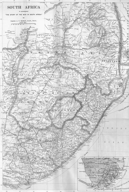
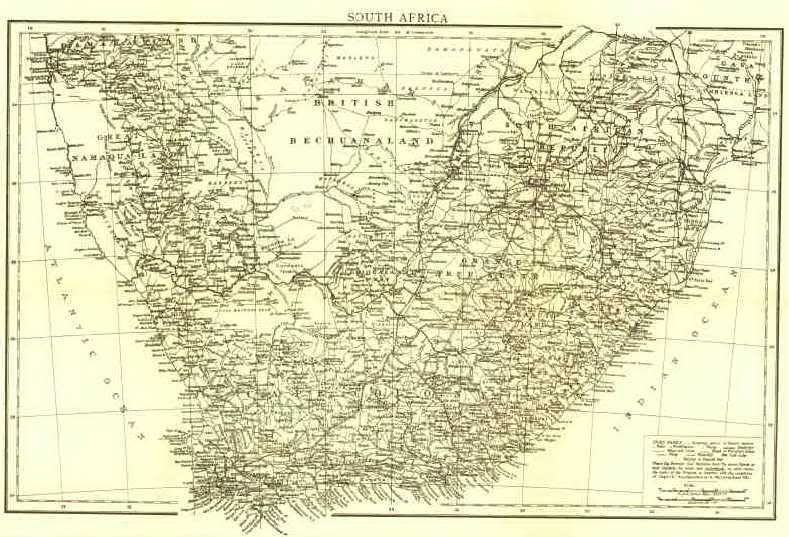
The movement of the Dutch inland, from Cape Colony towards the Kaffir country and through it in the direction of the Orange River, thence to the Vaal and the Buffalo, and finally to the Limpopo, began before the middle of the eighteenth century and continued until the Orange Free State and South African Republic were constituted as the seats of the Boer concentration.

Boer War for Independence 1795

By the year 1780, this progressive drift of population had extended to the Great Fish River, which was for a period the Boer frontier. Such was the situation in 1795, when the colonists at the Cape, catching the fever of revolution from Western Europe, determined to free themselves from the dominion of the home kingdom. They revolted and declared independence.

The Dutch authorities were at this time hard pressed by the continental revolution which had extended into the Netherlands. Hereupon Great Britain, seeing the inability of the Dutch to keep their grip on South Africa, and fearing that that country might be seized by the French, sent a fleet to the cape and took possession of the country in the name of the Prince of Orange.

Without much disturbance to the colonists, British authority was established over them. A British governor was appointed, and peace was maintained until 1802, when, by the treaty of Amiens, Cape Colony was restored to Holland.

Four years afterwards, the continental war broke out with more violence than ever, and the British, under Sir David Baird, again took possession in South Africa. This assumption was maintained for nine years, when it was confirmed forever, at the Congress of Vienna. A new inap of the world was there constructed. Changes were effected in all the continents and in most of the archipelagos. Cape Colony was ceded I)y the King of the Netherlands to Great Britain, together with Ceylon, Dutch Gui aina, Mauritius, Tobago, Malta, and Helgoland. The aggregate result was to make the future possessions of the Dutch in South Africa an inland dominion.

British Cape Colony was now made to extend from the mouth of the Orange River all the way around the southern bend of the continent to the mouth of the Tugela. As for the Boers, they virtually lost their statehood and became a people, without definite territorial demarcations.

Such is the story of the Dutch in South Africa down to the Berlin Conference of 1884. After that date, a number of European states appeared on the map, the history of each of which the Orange Free State and the South African Republic included, will be noted in subsequent chapters down to the time of the Jameson episode.

Labels:

Thursday, January 25, 2007

Somalia Development

The entirely readable Washington Times has a story about U.S. citizen/terrorists that have been captured. WTF! Also, SOF continues to rock along and we continue to destroy the enemy. Isn't it nice what can be accomplished outside the MSM's ridiculous glare?

Labels:

The most popular Jewish rapper since MC Hammer

Craaazy Hebrew!

Labels:

The Boer Wars: Part VIII

Without drawing out our look at the Boer Wars indefinitely, it is still impossible to get into the meat of the War without a further look at the time preceding 1880. Rather than range back to the complete history of South Africa, we will begin our review of that time from the arrival of the Dutch. Here is that history from a Dutch period perspective.

The Dutch Enter Africa

by John Ridpath and Ed Ellis

Among modern maritime nations, Holland is second to one only, England. Her geographical position and the genius of her people have conspired to give her this enviable rank. Once and again the Dutch have been, not second, but first in the domination of the sea. This was in the seventeenth century, when the fleets of England herself, went back before the prowess of Van Tromp and De Ruyter. Time was in a still earlier age, when Dutch ships were second to none in their ocean Right to distant lands, whether to the Indies in the East, or to the frozen bay of Hudson, in North America.

Rise of the Netherlands

The rise of the Netherlands to influence at home and abroad dates from their great revolt against Spain in the year 1581. Long and dreadful was the contest which ensued. The Dutch were tried by fire and by water; for some perished in the flames of the Inquisition, while hundreds were drowned in their own North Sea, for the inrushing of which the patriot leaders had broken the dyke.

For nearly seventy years the conflict of the Dutch rebels with, their merciless adversaries continued. But they issued from their war of independence with hosannas and flying banners. Then their fearless spirit carried them forth to the ends of the earth. Long before the treaty of Westphalia (1648), when the independence of the Dutch Netherlands was finally acknowledged and guaranteed, the mariners of Holland had become conspicuous for their abilities as discoverers, explorers and colonizers. North America received their impress. The Indies, East and West, knew their forceful visitations, and Africa felt their tremendous impact.

The revolt of the Netherlands, occurred coincidently with the absorption of Portugal by Spain. With this event all Portuguese interests, whether at home or abroad, became constructively the interests of the Spanish crown. In her long war with the armies of Philip II, Holland might well attack the Portuguese possessions, since they were the dependencies of Spain. The situation as well as the spirit of the race brought the Dutch fleets to bear against the Portuguese, and made the colonial empire of the latter an easy spoil. Such was the condition which led inevitably to the overthrow of the East Indian dominion of Portugal, and the substitution therefor of the Oriental empire of the Netherlands.

Dutch Conquerors


The same thing virtually occurred on the coasts of Africa. Here the Dutch became the aggressors and the conquerors. The first trading expedition was sent out from the North Sea to Guinea in the year 1595. The ships of the Portuguese and the Spaniards could not withstand the onset of the hardy Dutch captains who assailed them. Neither could the French and English fleets bear the pressure of the new sea-power rising from the northern ocean.

In a short time, West Africa became the prey of the Dutch. In the first place, the island of Goree, belonging to France, situated off the coast of Senagambia south of the Cape Verde group, was purchased, colonized, and fortified.

In 1621, the Dutch West India Company, successor of the Dutch East India Company, was chartered, and from that time forth the fleets of Holland made their way west, south and east. They came upon the Atlantic coast of Africa, and there wrought havoc with the settlements of other nations.

In 1637, El Mina, the old stronghold of Portugal on the Gold Coast, was captured by the Dutch. Soon afterwards Axim was taken, and the other forts of the European colonists fell one by one. Wherever the Dutch landed, they first subdued and then fortified. Their charter gave them the monopoly of trade from the Tropic of Cancer to the Cape of Good Hope.

They proceeded accordingly to make valid their claim by conquest. They built forts at intervals all the way from Arguin southward to the extremity of the continent. The gold coast was, in particular, made secure against the onset of rivals and enemies. Between Cape Blanco and St. Paul de Loanda more than two score forts and stations had been established, and of these the Dutch gained possession of sixteen.

Then followed the opening of trade, or, rather, the transfer of the trade which the Portuguese had already established to the merchant ships of Holland.*

(* The commerce of the Portuguese, according to their own report, was described as "a very great and advantageous inland trade for some hundreds of miles." Nearly all of this, now went to the Dutch, and the saying got abroad, that the Portuguese were the "dogs which chased the game out of the jungle, in order that the Dutch might take it.")

At first the commerce was mostly of gold and ivory and pepper. But it was not long until the Dutch merchants yielded to the same temptation, before which, they of Lisbon and London had sunk into utter depravity.

The slave coast promised richer reward than did the coast of gold. The man-trade was more enticing than the trade in tusks and pepper-pods. This thing, indeed, had been contemplated from the very first; for the company was chartered as the Dutch West India Company. Why West India? Why, but to hint at the slave trade as the principal business for which the company was licensed? For a long time, the merchant ships of Protestant Holland were laden to the water with their cargoes of human chattels.

Great was the enmity of England on this score. Pain would the English ships have had a share in the profitable man-trade. The British planters in the West Indies mouthed not a little because the Dutch slave-ships brought only the refuse of their traffic to them. They got only the poorer sort of slaves, while the better were sold in Hayti and Cuba. The Dutch were monopolists in this traffic, and the English traders believed in no monopoly save their own.

How, hardly, would the latter consent to pay £ 20 per head for slaves, when with an African port of free entry for their own ships, negroes could be bought or taken for fifty shillings each! Nor do the writings of the times indicate any sentiment respecting the nefarious merchandise other than the desire to make from them the greatest possible profit!

During the early part of the seventeenth century, the situation here described, continued to prevail in the Dutch-African dependencies. Frequently in this age, the European nations were so greatly complicated by war and intrigue, that their outlying possessions were neglected, if not forgotten, in the deadlier struggle of armies and navies close to the home kingdoms.

Thus, for example; in the Cromwellian era, what could be expected but that the attention of England and the proximate continental states should be absorbed in the vicissitudes of that momentous conflict? Soon afterwards, Holland and England were engaged in a death-grip on the sea.

By a strange turn of events, however, when the Revolution of 1688 came, William the Stadtholder of the Netherlands, while retaining his continental rank, became King of England. The fleets of the kingdom and the republic were brought into union for fifteen years. For a considerable period the two countries made common cause on both land and sea, contending in a masterful way against the inordinate ambitions of Louis XIV of France.

Even on the African coast, the English and Dutch rivalries were abated, not to break out again until after the death of William III.

Labels:

Wednesday, January 24, 2007

The Boer Wars: Part VII

Offense vs. Defense

by Capt. Alfred Mahan

And here at once must be made a distinction, which for intelligent comprehension it is essential to keep in mind. Putting entirely to one side all question of the merits of the quarrel -- of its right or its wrong -- it must be steadily remembered that, although the comparative aggregate strength of the two parties placed the Boers from the first on the defensive in the general sense, they were at the beginning of hostilities decisively superior in local force, and would so remain until sufficient reinforcements from Great Britain should arrive to turn the scale.

Under such circumstances, correct military principle -- and the Boers have had good advisers -- imperatively dictates that the belligerent so situated must at once assume an active offensive. By rapid and energetic movement, while the opponent's forces are still separated, every advantage must be seized to destroy hostile detachments within reach, and to establish one's own front as far in advance of the great national interests, as it can be reasonably hoped to maintain it with communications unbroken.

The line thus occupied must rest upon positions so chosen that by their strength, natural and developed, it shall be possible, when offence has to be exchanged for defensive warfare, to impose to the utmost upon the invader both delay and loss; for delay and loss mean lessening power, and only by causing such diminution, greater relatively than his own, can the weaker hope eventually to reverse the odds and win the game.

To this end, therefore, the Boers with sound military judgment at once devoted themselves; and it is very likely that the surmise before quoted was correct in naming the Hex River Pass and Durban as their ultimate objectives, to be reached by a swift advance. The latter was certainly not an unreasonable hope, and it is possible that with more precise accuracy of combination, and an offensive more resolutely sustained, they might have attained their purpose, through the mistaken primary dispositions of the British, who, though recognizing themselves to be for the time on the defensive, nevertheless, for political reasons, advanced their front of operations to a point with which, as it proved, they could not secure their communications.

From the worst consequences of this error they were saved by the gallantry and skill with which advantage was taken of the defective co-operation that marked the opening of the campaign by the Boers; and there can be also little question that the wholesome respect for their fighting. qualities, thus established at the beginning of hostilities, had a most beneficial effect for them, in discouraging attack by an enemy, who, though brave and active, constitutionally prefers a waiting game to an assault.

Thus the ultimate fate of Ladysmith was settled in the fortnight of operations that preceded the investment.

Labels:

Tuesday, January 23, 2007

The Boer Wars: Part VI

Valley of the Tugela

by Capt. Alfred Mahan

Before proceeding to the narrative of the hostilities which, so far as events of decisive interest are concerned, began in Natal, it is desirable to note one broad topographical feature distinguishing the region to which, in its eastern development, the war has been confined.

From the capital, Pietermaritzburg, the railroad ascends rapidly, so that in twentyfive miles it has risen from 2,200 to 4,800 feet, after which it begins again to go down, till fifty miles further, at Estcourt -- the most southern of the stations prominently named in the narratives of the war -- the elevation is 3,800 feet.

Thence, till near Glencoe and Dundee, there is an extensive area of comparative depression, rarely itself higher than 3,500 feet, but on the western side skirted by the precipitous spurs of the border mountains, close to which the railroad passes.

This district may be called the valley of the Tugela ; for all the streams tend to the latter, which finds its own bed in a broad belt of ground, trending to the eastward, where the surface sinks to less than 3,000 feet.

Ladysmith itself, important not only as a railroad crossing and military depot, but now also historically, on account of the operations centering around it, is at a height of 3,300. Beyond it the country, though often rough in detail, is gently rolling in general contour till near Glencoe, where the road climbs eight hundred feet in ten miles. From Glencoe a branch runs five miles east to Dundee, the site of extensive collieries, upon which Natal largely depends for fuel.

The railroad from Ladysmith to Glencoe passes therefore through a district the nature of which is favorable to rapid advance or retreat of mounted men, as the Boer forces chiefly are, and which at the same time is marked by frequent and steep detached elevations, adapted for defensive positions hastily assumed.

These conditions, with the nearness of the declivities of the western mountains, and the proximity of the enemy's frontier, behind which movements of troops would be "curtained " -- to use a graphic military metaphor -- gave the Boers particular facilities for striking unexpectedly the railroad between Ladysmith and Glencoe, upon which, in defect of other transportation, the two British posts must depend for communication between themselves, and with their base on the sea.

Further to the south, movements of the same kind would be decisively more difficult. Not only would the Boers there be further from their base, and the British nearer theirs, but the country is less favorable to rapid horse movements, the line of the rail is contracted by lofty and continuous ranges of hills, the space between which gives but a narrow front to be covered by a defence, and the river beds, as already said, are broader and deeper; notably, of course, the Tugela.

Moreover, not only are the mountains on the western frontier higher and more difficult as one goes south, they are also more remote; and, south of Colenso, form the boundary of Basutoland, upon which the Boers could not intrude without arousing armed resistance by the blacks.

All these conditions are more favorable to a pure defensive attitude, which was that imposed at the outset upon the British, because they were then numerically the weaker party.

Labels:

Monday, January 22, 2007

A Gentleman's Guide

Here are some interesting thoughts on being a gentleman. Make sure you click through and read Grim’s take on it. Excellent stuff.


So a gentleman is much more than well-dressed and courteous. That being said, I recently picked up a small book on how to conduct oneself as a gentleman. It is more accurately a book on courtesy and manners for men (buncha animals). As I am currently into ongoing serial posting, this will be my first post relaying some of the information found therein (are you listening Jake Commando and Shamrock?)!

I must admit that this little book has made me look much better than I truly am in real life (not that my mother didn’t teach me well, just that we never got to tuxedo etiquette on the farm). There are copious amounts of nuggets here and I don’t believe all of them to be correct. In fact, I won’t post those that I find dubious. Now, I will shamelessly reprint some of these nuggets for you here. Easy to read, I recommend this book for anyone who has a high school or college age boy. Enjoy (and some of you should probably absorb… damned, dirty apes).


A Gentleman Experiences Real Life
  • A gentleman never makes himself the center of attention. His goal is to make life easier, not just for himself but for his friends, his acquaintances, and the world at large.
  • If a gentleman has a cold, especially if he is running a fever, he declines all social invitations. If it is possible, he even stays away from the office.
  • Because he respects other people, a gentleman always shows up on time for any performance, whether it is a concert, a motion picture, or a stage play. If he arrives late, he does not attempt to be seated until there is a suitable break in the performance. (In the case of a play or a musical comedy, his tardiness may require him to wait until intermission.) In every case, he follows the instructions of the ushers. If he behaves himself, a gentleman knows, a kindly usher may quietly ship him into a seat on the back row.
  • A gentleman never forgets that watching a live performance is not the same thing as watching a TV show in his own living room. He does not talk during the performance – even during the very loudest music or sound effects. He does not shift about in his seat unnecessarily. And, if he has a tendency to cough, he always carries a cough drop. Should a gentleman find himself surprised by an uncontrollable coughing jag, he leaves the auditorium – both for his own good and for the good of others.
  • At a concert of any other musical performance, a gentleman does not applaud until the end of a complete musical number. If he is unsure he would be well-advised not to start an ovation alone.
  • In a theater, a church, or any place where people have gathered to hear music, a gentleman always turns his mobile phone and beeper off.
So, what do you think? Worthy of further posts? I recognize, by the way, that I'm stating the obvious for anyone over the age of 35. What say you?

Labels:

Better Map

Labels:

The Boer Wars: Part V

Mountains and Rivers

by Capt. Alfred Mahan


"The mountains which on the edge of Basutoland rise to a height of ten thousand feet," writes Mr. Bryce, "break down toward Natal in tremendous precipices. Near Ladysmith the frontier of the Orange Free State coincides with a high watershed, crossed by only a few passes." (Impressions of South Africa. Third Edition, p.291.)


Where this boundary between Natal and the Free State ends, that of the Transvaal begins, and soon after turns sharply to the southward, the new direction forming with the old a very acute angle, with apex to the north.

Here, just within the territory of Natal, is Majuba Hill, whose name has been in the mouths of all men, and Laing's Nek, less familiarly known. The narrow neck of rugged country embraced between the legs of this angle is about sixty miles long, from Majuba to Glencoe. Recent events have familiarised to us many of the names along this line of rail -- Glencoe, Dundee (the terminus of a short branch), Colenso, Estcourt, and Ladysmith itself; while the winding character of the track, as mapped, compared with the, Free State road, sufficiently indicates the character of the country, in which obstacles have to be circumvented as well as overcome.

The grade is in places as high as one in thirty, though that is being reduced; but one in forty is common. Pietermaritzburg, the capital, fifty miles from Durban in a straight line, is 2,200 feet above the sea. Three hundred miles from its starting-point the road reaches an elevation of over five thousand feet, at Laing's Nek, through which it passes by a tunnel.

A topographical map of the country shows upon examination that the mountain range, which forms the western boundary of Natal toward Basutoland and the Orange Free State, and has a general north and south direction parallel to the railroad, throws off to the eastward spurs which, to repeat Mr. Bryce's expression, "break down in tremendous precipices," forming a succession of terraces.

Rivers

The gorges between these determine the direction of the river-beds whereby the rainfall pours down to the sea; and the general easterly course thus imparted is maintained and continued by the lie of the valleys, separating the successive hills through which the territory of Natal gradually rises to the northward. These various streams find their way sooner or later to the Tugela, itself one of the many, but which carries its own name until it reaches the Indian Ocean, some fifty miles north- east of Durban.

Of these watercourses, the Tugela, which the road crosses at Colenso, and the Mooi, some fifty miles south, have been most often mentioned. Another tributary called the Klip flows through the camp at Ladysmith. The channels which these streams have cut for themselves in time of torrent are both steepbanked and deep.

They are therefore among those accidents of the ground which, duly improved, can seriously affect military operations. The destruction of a bridge impedes the transport of troops and supplies; a sudden freshet, occurring in the midst of an extensive movement, may imperil an army by sundering its forces ; while of the utility of such natural trenches to the purposes of shelter and of defence, of awaiting attack, or resisting an advance, both the Tugela and Paardeberg have given recent striking illustration.

As a general rule such conditions favor the defence relatively to the offence ; the former, remaining comparatively motionless, is shielded by obstacles, to surmount which the assailant must expose himself in the open.

Thus they compensate for inferior numbers, which is usually the condition of the defence ; and they conduce to delay, ever a leading object in defensive warfare. Consequently, in the present hostilities they have helped the Boers. It may be added that their influence is most felt when the armies are face to face, or at least in touch.

Hence their existence near the scene of probable conflict, as in Natal, is a matter of more concern to the invader than when, as upon the Caee extreme of the scene of war, they are found beyond the range to which the defendant can safely extend his operations.

These successive watercourses indicate natural lines of defence, stronger or weaker according to their individual distinctive features. As the railroad, in its progress north, draws near the mountains in the neck of Natal, the streams show smaller volume and less developed channels. This comes from their having there a shorter course and descending from heights which, though still considerable, are decidedly lower.

But, while the streams become less conspicuous as obstacles, the ground toward the northward frontier is more broken and irregular, presenting numerous scattered hills, sometimes isolated, sometimes in small ranges or groups, which to a trained military skill afford positions too threatening to be disregarded, and yet which cannot be carried without heavy loss. This characteristic is observable in the neighbourhood of Glencoe, Dundee, and Ladysmith, and, as will be seen, exercised a determinative influence upon the fighting.

In the extreme north a similar condition is emphasized conspicuously at Majuba Hill and the surrounding country, which, however, and perhaps for that very reason, seem unlikely to play much of a part in the war now current.

Labels:

Saturday, January 20, 2007

The Boer Wars: Part IV

Lines of Communication: Part II
by Capt. Alfred Mahan

The difficulty of reinforcing railway carriage by any other system of road transportation is greatly increased by the local horse-sickness, from which three-fourths of the horses exposed to it die.

Reliance for that purpose, therefore, must be upon the ox-wagon, which for this reason, and owing to the open level character of the country, has in the past played a leading part in the South African migrations.

The main and subsidiary railroads thus summarized should, from the point of view of our subject, be considered as one, contributory to the advance of the British army over a substantially even country, which opposes few natural obstacles to such a movement, though here and there "accidents of the ground -- a range of hills, or a dry river-bed, as at Paardeberg -- may facilitate opposition by a military force.

The system receives no further support until Johannesburg is reached. There the railroad from Durban comes in, and, if its carrying capacity were adequate, which is doubtful, would enable the chief base of operations and main line of communications to be shifted to the nearer locality, retaining the Cape road only as secondary.

The advantage to the British of the line of invasion from Cape Town is that it crosses the mountains, which separate the coast district, from the inland plateau, at such a distance from the enemy's frontier that it is impossible for the latter to offer serious resistance before the comparatively easy rolling country has been reached. It was for this reason that the decision of the Orange Free State to join in the war, while it added to the numerical resistance to be encountered by the British, had for them the compensating advantage that it removed the necessity of forcing their way over the difficult mountain ranges which separate Natal from the Transvaal.

With the power of Great Britain to bring into the field a great superiority of numbers, it is at least open to argument that the Free State, by ceasing to be neutral, relieved the enemy of a difficulty greater than that which its hostility introduced. It was for these reasons that the original British plan, as generally understood, was to make the main invasion along this line.

The danger of Ladysmith, it is commonly and with probability believed, caused the momentary abandonment of this purpose. Whether the change was at the moment correct in principle or not, it is evident that Lord Roberts has reverted to the first intention; a course which enforces its accuracy with all the weight of his well-earned great renown.

The other railroad system of direct importance to the military operations of the present war is the single Natal line, from Durban to Johannesburg and Pretoria, which at Ladysmith throws off a branch to the westward, crossing the mountains to Bethlehem in the Free State, and there ends, over sixty miles from the road between Bloemfontein and Pretoria.

The Natal road, having been opened as lately as 1895, may be considered the child of the Gold Fields; prior to the discovery of which, indeed, there were in the Transvaal neither products nor consumers enough to give commercial value to a railroad.

The Cape Town line reached Pretoria only in 1892, and it is still characteristic of all the lines that there is but little local traffic, either freight or passenger ; the roads exist as means whereby the function of communication, so far discharged by the sea, is prolonged from the coast to the interior of the continent.

It is not the least noteworthy in the incidents of commercial and mechanical energy, by which foreign hands have developed the Transvaal from a poor to a wealthy state, that "all the heavy machinery, the timber, the corrugated iron with which the works and men's houses are constructed, ahd nearly every requirement of work and life, had to be brought for over three hundred miles upon ox- wagons, the country itself supplying scarcely anything, and even to this day (1897) wheat being brought from Australia." (Younghusband's "South Africa of Today." Second Edition, 1899.)

Regarded as a source of supply, especially of military supply, the demands of which are more urgent than those of common life, as its needs and dangers are more imminent, the Natal railroad, though much shorter in distance to the probable scenes of operations, labours under two disadvantages.

The port of Durban is not under all circumstances safe for large vessels to enter, and there is therefore in the facilities for landing goods an inferiority to Cape Town. The country, too, is more difficult, the obstacles to movement, which also favour defence, increasing as the frontier is approached, and culminating on the borders of the Free State and the Transvaal. Being thus nearer, the latter are here better able to concentrate and sustain opposition than they are on the western flank.

Labels:

Friday, January 19, 2007

The Boer Wars: Part III

The Lines of Communication: Part I
by Capt. Alfred Mahan


The same conditions, unfavorable to the aggregation of people into towns or villages, have interfered with the development of lines of travel, roads and cross-roads, which not only facilitate but define movement; and as the face of, the country, readily traversable in all directions, does not compel roads to take a particular direction to avoid obstacles, it has come to pass that the seat of war within the territory of the two Boer states has, like the ocean, and for the same reasons, few strategic points either natural or artificial.

The determining natural military features in South Africa are the seaports, upon possession of which depends Great Britain's landing her forces, and the mountain ranges, the passes of which, as in all such regions, are of the utmost strategic value. It has been said that the Boers' original plan of campaign was to force the British out of Natal, thus closing access by Durban from the sea, and at the same time to seize the pass back of Cape Town known as Hex River. If successful, the eastern flank of the Boer frontier would have been secured against British landing by the occupation of Durban, while advance from Cape Town, against the other extremity, would have involved a front attack upon a strong position in a difficult mountain defile.

These movements, accurate in conception, were probably in any case too developed for the Boer numbers, and were definitively foiled by the British grip upon Ladysmith and Kimberley. Advance was too hazardous, leaving in the rear such forces, unchecked, upon the flank of the lines of communication.

To these two extremes, or flanks, of the Boer frontier, correspond on the British side the ports of Cape Town and Durban, which may be said to mark the western and eastern limits of the field of military operations in the war. They are the chief sea-ports on the South African coast, which by nature is singularly deficient in good and safe anchorages. The advantages of these two, artificially improved, and combined with the relatively open and productive region immediately behind them, have made them the starting-points of the principal railroad lines by which, through the sea, the interior is linked to the outer world.

The general direction of these roads is determined, as always, by the principal objects of traffic or other interests. Thus the line from Cape Town, ascending by a winding course through the mountains in the rear, pushes its way north to Kimberley, where are the great diamond fields, and thence on, by way of Mafeking, to the territory of the British South African Company -- now known as Rhodesia.

This lies north of the Transvaal, and, like it, is separated from the sea by the Portuguese dominion, having, however, by treaty a right of military way through the latter by the port of Beira; of which right use is now being made.

In the northern part of its course, which at present ends at Buluwayo, this road is as yet rather political than economical in its importance, joining the British entrance at the sea to the as yet little developed regions of the distant interior.

At a point called De Aar junction, five hundred miles from Cape Town, a principal branch is thrown off to the eastward to Bloemfontein, the capital of the Orange Free State, whence it continues on to Johannesburg, the great industrial Centre of the Gold Fields, and to Pretoria, the capital of the Transvaal. A glance along this stretch of road will show that between De Aar and Bloemfontein it receives three tributary routes from three different points of the seacoast -- Port Elizabeth, Port Alfred, and East London -- the whole system concentrating some sixty miles before Bloemfontein, at Springfontein, which thus becomes a central depot fed by four convergent, but, in their origin, independent streams of supply; an administrative condition always conducive to security and to convenience.

This instance also illustrates the capital importance especially in a military point of view of a place where meet several roads from the permanent base of operations, which in the case of the British interior campaign is the sea. The fall of Springfontein would close every avenue of supply by rail; but a blow at any one of the four lines which concentrate there does not necessarily affect the others. Holding a cross-roads in fact exemplifies the homely phrase of killing two birds with one stone.

Beyond Springfontein the straightness of the line sufficiently testifies to the easy practicability of the country it traverses. Upon this railroad system depend the supplies of the British army, which presents in both men and animals a concentrated mass of life heretofore unknown to the territory in which it is moving, and where, from previous conditions of population and development, necessary resources of every kind are deficient. This system constitutes the main chain of communications, as the term is understood in war; by it chiefly, for much of the distance wholly, must come all the ammunition, most of the food, and not improbably at times a good deal of the water drunk during the dry season, which fortunately, from this point of view, is also that of cooler weather.

Labels:

Thursday, January 18, 2007

Gay's Anatomy

My wife and I watch this truly crappy show called "Grey's Anatomy." Recently it was revealed that the guy who plays that monumental pussy named George... is gay. I'm sorry, you mean someone actually thought he was straight? Puulease.

One of the things that my wife likes about me and my buddies (think doorkickin' military) is that we are "men." There is virtually no ambiguity and homo-erotic banter is greeted with guffaws and snappy comebacks. For example, I've spooned with buddies on freezing nights in the field. One buddy actually saved me from dying from hypothermia that way. Hey thanks, Bill... by the way, don't think I didn't notice the wood... homo. See?

Labels:

The Boer Wars: Part II

Terrain of the Country

by Capt. Alfred Mahan


The mention of this migration leads naturally and immediately to a summary of the physical conditions of the country, by which, as well as by derivation of blood, the apartness of the two races has been emphasized. Between the narrow margin of land belonging, as it were, to the sea, and the high interior plateau, there runs from the extreme west of the British dominions a chain of lofty mountains, parallel, roughly, to the coastline, and terminating only when abreast of Delagoa Bay. These reach an elevation of from six to eight thousand feet, and in places on the border between Natal and Basutoland heights of eleven thousand are attained.

On the side toward the sea the ascent is comparatively rapid and difficult, though often broken into precipitous terraces. Inland the descent is less, and more regular, issuing in a plateau from three to five thousand feet above the sea, and presenting almost throughout a comparatively level or undulating surface that offers no serious difficulty to transit.

The territory of the Orange Free State and of the Transvaal lies wholly within this tableland. In this region, and throughout Africa south of 25 degrees there are river beds, but no navigable rivers. The country is generally treeless, and there is a great deficiency of steady natural water supply. During the rainy season, from October to March, the naked ground fails to retard the running off of the waters, which therefore escape rapidly by the rivers, swelling them to momentary torrents that quickly and fruitlessly subside. During the long dry season the exposed herbage dries to the roots.

From these conditions it results that not only is agriculture generally impracticable, economically, but that cattle and sheep, the chief wealth of the Boer farmers, require an unusual proportion of ground per head for pasture; and the mobility of bodies of horsemen, expecting to subsist their beasts upon local pasturage, is greatly affected by the seasons-an important military consideration.

The large holdings introduce large spaces between the holders, who dwell therefore alone, each man with his family. So it has come to pass that the descendants of one of the most mercantile and gregarious of races, whose artists have won some of their chiefst triumphs in depicting the joyous episodes of crowded social life, have, through calling and environment, become lovers or solitude, austere, self-dependent, disposed rather to repel than to seek their kind.

Labels:

Wednesday, January 17, 2007

The Boer Wars: War in South Africa 1880-1902

This is the first post in a series of posts regarding the history of The Boer Wars. That's right, a history and analysis of the Boer Wars in bite-sized chunks. Much of the early posts will be dispatches from that time and place. Why these particular wars? Read along over the next couple of weeks and see why...


History of the Area
by Capt. Alfred Mahan

The war in South Africa has been no exception to the general rule that the origin of current events is to be sought in the history of the past and their present course to be understood by an appreciation of existing conditions, which decisively control it. This is especially true of the matter here before us, because the southern extreme of Africa, like to that of the American continent, has heretofore lain far outside of the common interest, and therefore of the accurate knowledge, of mankind at large.

The Cape of Good Hope and Cape Horn, in themselves remote, tempestuous, and comparatively unproductive regions, for centuries derived importance merely from the fact that by those ways alone the European world found access to the shores of the Pacific and Indian Oceans. The application of steam to ocean navigation, and the opening of the Suez Canal, have greatly modified conditions, by diverting travel from the two Capes to the Canal and to the Straits of Magellan.

It is only within a very few years that South Africa, thus diminished in consequence as a station upon a leading commercial highway, has received compensation by the discovery of great mineral wealth.

Thus separated from the rest of the world, by lack of intrinsic value as a region producing materials necessary to the common good, the isolation of South Africa was further increased by physical conditions, which not only retarded colonisation and development, but powerfully affected the character and the mutual relations of the European settlers.

Portuguese mariners, after more than half a century of painful groping downward along the West African coast in search of a sea route to India that vague tradition asserted could there be found, in 1486 rounded the Cape of Good Hope, which then received the despondent name of Cape of Storms from its first discoverer, Bartholomew Diaz.

Vasco da Gama, following him in 1497, gave to it its present auspicious title, which was to him of sound augury; for he then passed on to explore the East coast and to find the long-desired Indies. It was, however, the latter which constituted the Portuguese goal.

Africa was to them primarily the half-way house, where to refresh their ships on the long voyage to Hindustan, which then took near a year to complete. For this purpose they established themselves on the island of Mozambique, and gradually took possession of the country to this day known as Portuguese East Africa.

From that far back settlement, Delagoa Bay, near the southern border, is now a thorn in the side of the British invasion a port with which they are not at war, and therefore cannot seize or blockade, but which, through the supplies that thence reach the otherwise isolated Transvaal, contributes powerfully to support the defence.

Upon the heels of the Portuguese followed the Dutch, aiming like them at the Far East, more especially at what were then comprehensively called the Spice Islands -- the Moluccas. They also felt the need of a half-way station. For this the Cape of Good Hope, with the adjacent bays -- Table Bay and False Bay -- presented advantages; for though not perfectly safe anchorages at all seasons, the voyage to the islands is more expeditiously and healthfully made by starting from, and keeping in a far southern latitude, than by proceeding along the East African coast.

In 1652 the Dutch settled at the Cape, and gradually extended their holding to the eastward as far as the Great Fish River. A generation later, in 1686, the population received an accession of French Protestant refugees, leaving their country upon the revocation of the Edict of Nantes.

From these descended the late General Joubert, Commander-in-Chief of the Transvaal forces at the opening of hostilities. The administration of the colony by the Dutch East India Company being both arbitrary and meddlesome, some of the more independent spirits withdrew from the coast and moved inland, behind the difficult mountain ranges that separate the narrow strip of sea-coast from the high table-lands of the interior.

In 1795 local dissatisfaction and the spread of French revolutionary principles led to a revolt of the colonists, and Holland passing at that time into alliance with France, the Cape was seized by a British naval and military expedition.

At the Peace of Amiens in 1802 it was restored to Holland; but in the next war it was again taken by the British, in 1806, and at the Peace of 1814 was confirmed in their possession.

The population remained Dutch in blood and in tradition ; but subsequent accessions of English immigrants have established in Cape Colony itself an approach to equilibrium between the two races, to which has also contributed a series of emigrations to theinterior by the Dutch farmers, dissatisfied with various incidents of British rule. Into the merits of these differences we have neither space nor occasion to go.

In 1836, immediately prior to the largest of these movements, known as the Great Trek, the British Government, by Act, extended its claim of control over all South Africa, south Of 25', the latitude of Delagoa Bay; and the Boer emigrants were warned that in entering that region they remained under British authority, unless they passed on into the Portuguese dominion.

From this Trek resulted directly, in the course of years, the two Boer states, the Orange Free State and the South African Republic (commonly called the Transvaal); and also, indirectly, the easternmost British colony in South Africa, Natal, in which the English element is decisively preponderant.

Labels:

Craaaazy Links Wednesday!

Hey, at least I'm managing to post...

Please, please, gentlemen. Do not click here.

Dumbass.

My not-so-secret crush continues… Poor, poor girl.

Great, and it’s AFTER Christmas.

If I were there, I’d already be some Swell, Beefy Fella’s (SBF) bitch. This post is a good example.

Labels:

Monday, January 15, 2007

Movie Review: We Are Marshall


What can I say? Clearly I'm a sucker for football movies (though going to see Any Given Sunday was time I'll never get back). I suppose that with a few exceptions (like Friday Night Lights) it would be most accurate to say that I'm a sucker for football movies based on a real story.

Marshall was worth the money I spent on ticket, popcorn, and drink (about $800). As my readers know, I'm a huge fan of optimism, and this move is awash in hard work and positive thinking. I suppose that after all these years I'm more inclined to watch movies that will lift me up rather than simply dull my brain. This is one of those. I'll purchase this movie and put it up on my shelf near (not next to) Rudy, Brian's Song, and Invincible (among others) that I'll encourage my son to watch.

Labels:

Friday, January 12, 2007

What is it with the Videos?


This is pretty damn funny.

via Ace.

Labels:

Thursday, January 11, 2007

Karaoke for the Deaf

Labels:

Tuesday, January 09, 2007

More Analysis!

Looking back over the last couple of months, I noticed a trend. I haven't given you, my gentle readers, any analysis or commentary worth returning on a daily basis. I've been so preoccupied with business that I really haven't taken the time to pass on my massive amounts of bleary-eyed wisdom to ya'll. So, without further ado...


THE BCS SUCKS! Okay, I'm not a fan of Ohio State (even though they are Big Ten) but these teams played their last games SIX WEEKS ago! WTF! The real national championship game IMHO was Michigan v Ohio. Teams are in the groove... tired... traveled... and as raw as you're likely to see them. Waiting five or six weeks means that you are seeing an entirely different team playing. Ohio completely destroyed every single other team this year. The Gators, however, (again, IMO) weren't playing to potential all year. I don't know, I just miss having all the college games over on New Year's Day (latest) and championships decided a bit more realistically. I'm tired of being uninspired that teams are playing in the Chik-Fil-A Bowl. That being said... the Gators were clearly the best team last night. An incredibly disappointing end to the BCS process.

My hat is off, however, to Boise State for giving this Squirrel possibly the all-time best Bowl Game EVER. Thank God for you!

More analysis/rant coming later today!

Labels:

Monday, January 08, 2007

Winna, Winna, Chicken Dinna!

Yep, I won week one of the Squirrely Biggest Loser! Woo Hoo. Unfortunately, guys always rock at the beginning. I lost seven pounds last week and really only have another 15 to go before I hit my goal weight. In short, there is no freakin' way that I'll repeat that amount next week. I kinda screwed myself. Anyway, I do feel better and am already experiencing increased energy levels. Nice.

Labels:

Saturday, January 06, 2007

Quality Remix

An awesome example of creative editing.
I would actually pay to see this one!

Labels:

Where Did the Week Go?

Wow, that really flew by quickly. I've been so busy that I haven't taken time to enjoy much of anything. Bummer. Ah well, too much work to do this weekend.

The whole "getting into shape thing" is going well (I think, I don't weigh in until tomorrow) but at least this hasn't happened to me, which is nice. And, it will be awhile before I can do this.

Labels:

Tuesday, January 02, 2007

The Biggest Squirrely Loser

The wife and I have started a little household competition. It is the Biggest Loser... Squirrel Style. So we weighed in yesterday morning (Monday, 01 Jan 07) and will weigh in every Monday until April 2nd. Each week, the one with the highest percentage lost will win some sort of prize (TBD, although mine will probably involve a nurses outfit, handcuffs, and toothpaste... just sayin'). The final weigh-in and total percentage "loser" will win the grand prize. We still don't know what that is, but it will be really, really good (although, to be fair, what is better than ass-less chaps, a rented casket, and baby oil?!? Seriously..).

This otta be fun.

Labels:

Monday, January 01, 2007

Happy New Year!

I'll be spending the day with the kinder, while Sexy Squirrel heads out to a scrapbooking event. Hope you have a fantastic one!

Labels: